
Egypt Geography
Egypt can be divided geographically into two main sections, as Egypt was located in North Africa, while the Egyptian Sinai peninsula, south-west Asia.
Egyptian border
-western border It is the between Egypt and Libya, which is a border line, a distance of 1049 km and extends as far south as straight complete the tri-border convalesce for a distance of 804 km and appears to winding of the Siwa Oasis to the north to a distance of 290 meters, so a combination of reduction and reducing the astronomical engineering.
2 - the eastern border between Egypt and Palestine to begin from the top of Taba on the Gulf of Aqaba coast of the Mediterranean and even to a distance of 210 km and this is consistent with the line along the 34 east. And Egypt has also limited the Red Sea from the Middle Boukljugip Suez and Aqaba.
3 - the southern border between Egypt and Sudan on the line of engineering Itaamd natural and human phenomena and extends with the direction of the Middle Owainat about the Nile River and is in the middle of this reduction and the Nile Valley, and even complement the Red Sea, when the cities of Halaib and Shalatin Egyptian.
4 - the northern border the Mediterranean Sea and is a natural end overlooking the emergence of the Mediterranean Sea, where the northern boundary extends from the east of Rafah, the Egyptian town of Salloum to the west, where a distance of thousand kilometers. At this point there are three water border of Egypt with all of Cyprus and Turkey and Greece.
Provinces Egypt (states)
Egypt is divided into 28 provinces. Cairo, Giza, Alexandria, Aswan Helwan October 6 New Valley Qena South Sinai North Sinai, Assiut, Minya, Sohag, Beni Suef, Fayoum, Ismailia Qaliubiya Dakahliya lake is West Damietta Port Said Suez Monoufia Kafr el-Sheikh Red Sea, East
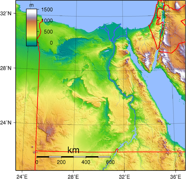
Natural division
More than 75% of Egypt's area within the tropical dry desert region

First: The Western Desert of Egypt:
Bordered by the Mediterranean Sea from the north and Libya on the west and the Nile Valley in the east and an area of 681 thousand square kilometers and appears closer to a rectangle and the most important characteristic of Western Sahara and low Owainat Mount Dropper is distinct regions known as Western Sahara, the northern coast and the most important of Marsa Matrouh, where agriculture water Rain and groundwater through shallow wells, which defines Balsoany
Second: the Nile Valley and Delta:
River Nile is a distance of 1536 km within the Egyptian territory and take into Egyptian territory, where several directions is alternately to the north-east and then north and the other is to the north-west and then to the north and the estimated number of islands of the Nile River island of Ngo 300 Islands of the mud deposits of the Nile River, most of haunted and some are a key part of the important cities, such as the island of Zamalek and the school in the city of Cairo and there Jeranite such as the Aswan Island and the Isle of Selloukh and Sohail
Nile Delta: with two branches, one along the Damietta branch of 245 km and an average 286 meters and the presentation of inches higher than the level Rashid Branch Bnhor last two and less along the -239 km - but more broadly from the Damietta branch - 554 meters on average - there are lakes and coastal discriminate Shal Aldltaoi is Manzala Lake, Lake Prince and BG
Third: the Eastern Desert:
1 - the coast line of the beach extends from the top of the Gulf of Sudan to the borders with Sudan and extending in a straight majority of sectors along with the Japanese head of the most important ground Jmsp and Ras Abu Somp show several islands to the coast, the most important and largest island of Cduan 2 - Mountain Red Sea is a set of blocks mountain, which extends straight from the sea close to where you just go south 3 - Alhilli scale is the Hipti Majesty's navy and to the north, tribal Alajellalh The main part of the plateau is the plateau and the limestone plateau Almezp Alababdp
IV: Sinai Peninsula:
And is divided into three sections
1 - the northern section is known Balshol North
2 - the middle area of this section is one third of the Sinai, and appear in this section and the limestone plateau wilderness called this name because of the Jews out of Egypt and later in the Tahoua region 40 years and in the south of Plateau, the smallest kernel of the hill Now
3 - Triangle firearm south of the Sinai is multi-edged mountain peaks and the most important summits of the mountain close to some of the top of Mount St. Catherine, the highest mountain peak in the 2600 Egypt-fertilization
2 - the eastern border between Egypt and Palestine to begin from the top of Taba on the Gulf of Aqaba coast of the Mediterranean and even to a distance of 210 km and this is consistent with the line along the 34 east. And Egypt has also limited the Red Sea from the Middle Boukljugip Suez and Aqaba.
3 - the southern border between Egypt and Sudan on the line of engineering Itaamd natural and human phenomena and extends with the direction of the Middle Owainat about the Nile River and is in the middle of this reduction and the Nile Valley, and even complement the Red Sea, when the cities of Halaib and Shalatin Egyptian.
4 - the northern border the Mediterranean Sea and is a natural end overlooking the emergence of the Mediterranean Sea, where the northern boundary extends from the east of Rafah, the Egyptian town of Salloum to the west, where a distance of thousand kilometers. At this point there are three water border of Egypt with all of Cyprus and Turkey and Greece.
Provinces Egypt (states)
Egypt is divided into 28 provinces. Cairo, Giza, Alexandria, Aswan Helwan October 6 New Valley Qena South Sinai North Sinai, Assiut, Minya, Sohag, Beni Suef, Fayoum, Ismailia Qaliubiya Dakahliya lake is West Damietta Port Said Suez Monoufia Kafr el-Sheikh Red Sea, East
Natural division
More than 75% of Egypt's area within the tropical dry desert region

First: The Western Desert of Egypt:
Bordered by the Mediterranean Sea from the north and Libya on the west and the Nile Valley in the east and an area of 681 thousand square kilometers and appears closer to a rectangle and the most important characteristic of Western Sahara and low Owainat Mount Dropper is distinct regions known as Western Sahara, the northern coast and the most important of Marsa Matrouh, where agriculture water Rain and groundwater through shallow wells, which defines Balsoany
Second: the Nile Valley and Delta:
River Nile is a distance of 1536 km within the Egyptian territory and take into Egyptian territory, where several directions is alternately to the north-east and then north and the other is to the north-west and then to the north and the estimated number of islands of the Nile River island of Ngo 300 Islands of the mud deposits of the Nile River, most of haunted and some are a key part of the important cities, such as the island of Zamalek and the school in the city of Cairo and there Jeranite such as the Aswan Island and the Isle of Selloukh and Sohail
Nile Delta: with two branches, one along the Damietta branch of 245 km and an average 286 meters and the presentation of inches higher than the level Rashid Branch Bnhor last two and less along the -239 km - but more broadly from the Damietta branch - 554 meters on average - there are lakes and coastal discriminate Shal Aldltaoi is Manzala Lake, Lake Prince and BG
Third: the Eastern Desert:
1 - the coast line of the beach extends from the top of the Gulf of Sudan to the borders with Sudan and extending in a straight majority of sectors along with the Japanese head of the most important ground Jmsp and Ras Abu Somp show several islands to the coast, the most important and largest island of Cduan 2 - Mountain Red Sea is a set of blocks mountain, which extends straight from the sea close to where you just go south 3 - Alhilli scale is the Hipti Majesty's navy and to the north, tribal Alajellalh The main part of the plateau is the plateau and the limestone plateau Almezp Alababdp
IV: Sinai Peninsula:
And is divided into three sections
1 - the northern section is known Balshol North
2 - the middle area of this section is one third of the Sinai, and appear in this section and the limestone plateau wilderness called this name because of the Jews out of Egypt and later in the Tahoua region 40 years and in the south of Plateau, the smallest kernel of the hill Now
3 - Triangle firearm south of the Sinai is multi-edged mountain peaks and the most important summits of the mountain close to some of the top of Mount St. Catherine, the highest mountain peak in the 2600 Egypt-fertilization
0 التعليقات:
Post a Comment